
Last month, NatureScot imposed a three-year General Licence restriction on part of Invermark Estate in the Angus Glens, in relation to the discovery of a shot Peregrine that was found on 3 September 2024. The Peregrine’s gunshot injuries were severe and it later had to be euthanised. Nobody has been charged or prosecuted in relation to this crime.
A statement attributed to Invermark Estate was published as part of an article in The Courier on 7 August 2026, the day the three-year General Licence restriction was announced. The statement read as follows:
The General Licence restriction was suspended two weeks after it was imposed as Invermark Estate had decided to make a formal appeal to NatureScot against the restriction. That appeal is currently ongoing.
When I wrote about that appeal, and published Invermark’s statement, I said it contained some interesting claims and that I intended to return to it in a future blog.
The first point of interest in Invermark Estate’s statement was the revelation that the shot Peregrine had been found “in the garden of a cottage“. This information was not previously available in the public domain.
The reason this information is of interest is because it allows us to pinpoint the location. It was already known that the General Licence restriction was imposed on tenanted land associated with Dalbrack Farm, as made clear in NatureScot’s restriction notice:
‘In the case of Invermark Estate, the restriction will apply to the Dalbrack Farm area of the estate. NatureScot received robust evidence from Police Scotland in relation to the shooting of a peregrine which was discovered in this area’.
An examination of several maps shows that there’s only one cottage in this immediate area – Dalbrack Cottage, which neighbours Dalbrack Farm. It’s my understanding that Dalbrack Farm is tenanted, and Dalbrack Cottage is sub-tenanted.

You’ll notice that Invermark Estate’s statement included the following carefully chosen words:
“While Invermark Estate owns the land in question, it does not manage it and there is no sporting activity where the bird was found (in the garden of a cottage)“.
Whilst this statement may be accurate, I would argue that it’s tightly worded and fails to inform the reader that the cottage in question is situated right on the edge of a grouse moor (remember, the Courier readers didn’t have the benefit of seeing a map). It looks to me like a deliberate attempt by Invermark Estate to infer some considerable distance between the estate’s grouse shooting activities and the garden of the cottage, because it fails to mention the proximity of the grouse moor and some of the estate’s grouse butts, which according to maps, are just metres away:

And these are not the only grouse butts in the area, as you can see from this map showing the part of Invermark Estate close to Dalbrack:
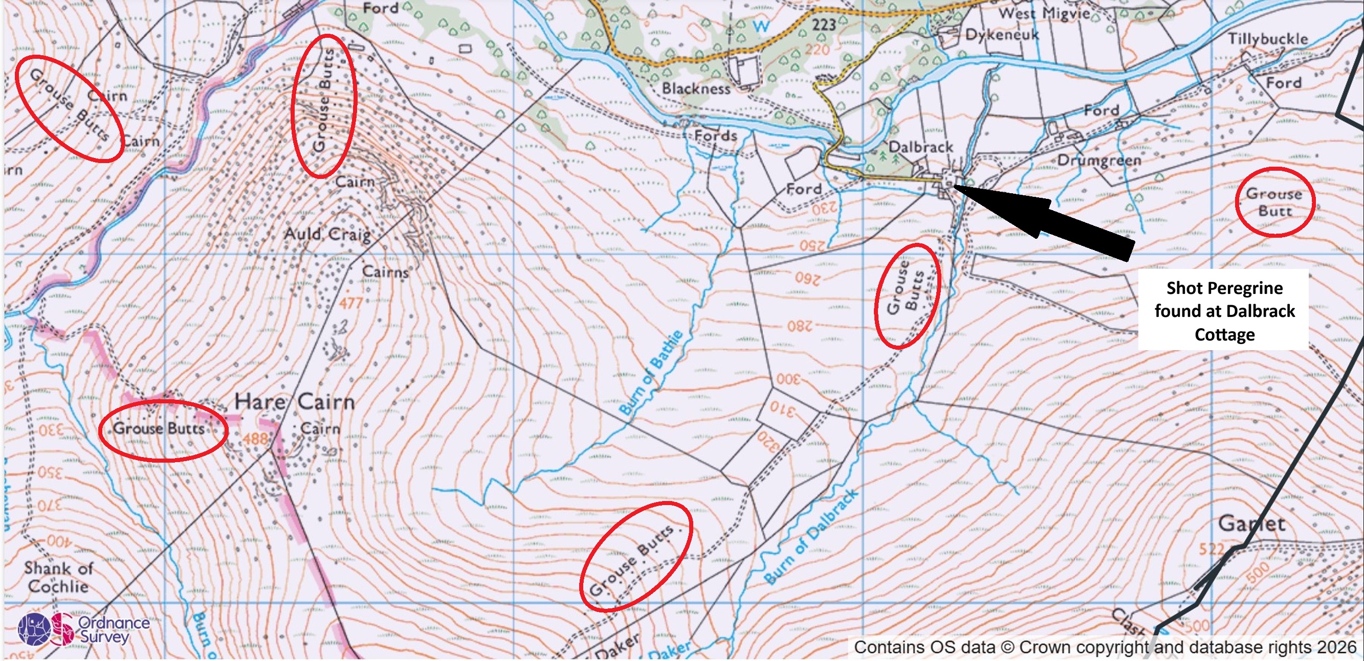
What this map doesn’t tell us, of course, is whether these grouse butts are still in use; they could have long been decommissioned and are now just historical cartographic relics. This brings me to the second point of interest in Invermark Estate’s statement:
“While grouse shooting does take place on land some distance away, the vet who examined the bird concluded that it could not have flown any distance because of its injuries and that the shooting must have happened close to the locus“.
Unlike Invermark Estate, the general public has not been afforded sight of the post mortem report so we’re having to reply upon Invermark Estate’s claim about what it says. Would it be feasible for the bird to have been shot further up the hill and then it glided down to the cottage garden where it crash landed at the bottom of the hill, without having had to flap its wings? Instead of having to rely upon Invermark Estate’s claim, I’d rather see the PM report for myself so I’ve requested a copy via FoI from NatureScot. If/when it’s released, I’ll post a copy here.
But what I can test is Invermark Estate’s claim that “grouse shooting does take place on land some distance away…“.
The phrase “some distance away” is quite subjective, isn’t it? What does it mean? A few metres, a few kilometres, a few glens away? The inference is that grouse shooting does not take place nearby [to where the Peregrine was found with shotgun injuries].
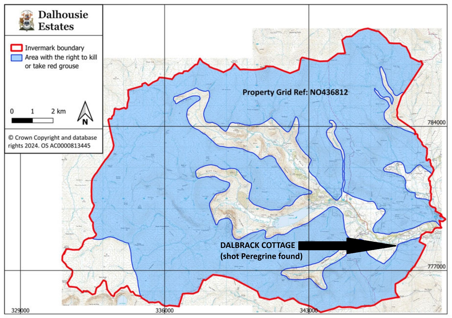
How interesting, then, to see the map that Dalhousie Estates (owner of Invermark Estate) submitted to NatureScot as part of its application for a grouse shooting licence. I sourced this map via an FoI and have annotated it to show the location where the injured Peregrine was found. It looks pretty clear to me that Invermark Estate’s estimation of “some distance away” is quite different to mine and probably that of most other people!
The third and final point of interest (for now) in Invermark Estate’s statement is this:
“It is difficult to accept this restriction when no allegation has been made that our organisation was responsible for the offence, and equally difficult to see how imposing such a significant restriction upon us can represent a fair or proportionate outcome“.
Invermark Estate has claimed that ‘it doesn’t manage the land in question’ and that “An agricultural tenant and sub-tenant have full control over the land, and that tenancy agreement has been in place for more than ten years“.
It isn’t clear to me whether Invermark Estate is claiming it doesn’t manage the land where the injured Peregrine was found or whether it’s claiming it doesn’t manage ‘the land in question’, which I take to mean the land covered by the General Licence restriction.
If it’s the latter, then why would Invermark Estate be so concerned about what it describes as “such a significant restriction upon us“? How could it be a restriction, significant or otherwise, if Invermark Estate has no involvement with the management of the land under restriction?
If it’s the former, then why didn’t Invermark Estate make it clear in its statement that it manages the land for grouse shooting in immediate proximity to where the injured Peregrine was found?
It’s worth looking again at the area of restriction imposed by NatureScot, and comparing it with Invermark Estate’s grouse shoot licence boundary map.
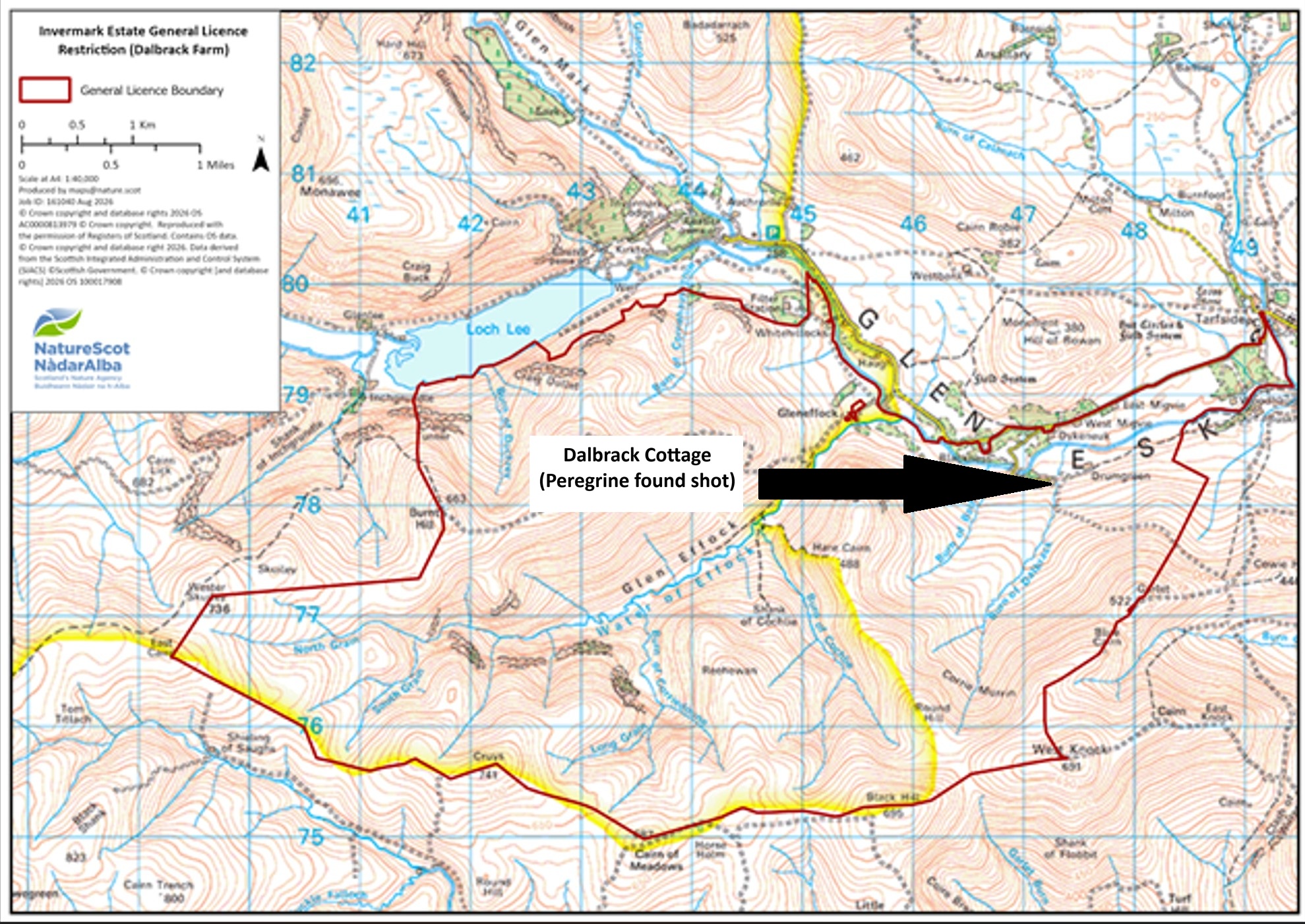
Here is NatureScot’s map showing the area of General Licence restriction (map annotated by me to show the location of the injured Peregrine):
And here is the General Licence restriction area (purple dotted line – note, this is not precise) overlaid on to Invermark Estate’s grouse shoot licence boundary map, with a black star denoting the location where the injured Peregrine was found:
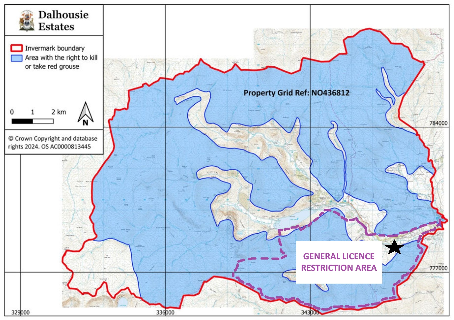
It’s clear then that the General Licence restriction area overlaps with a considerable chunk of moorland where Invermark Estate has the right to kill or take Red Grouse.
Are we to believe that Invermark Estate “does not manage” the land it owns and where the estate has a licence to shoot Red Grouse?
That would be extraordinary.
I await the outcome of Invermark Estate’s appeal against its General Licence restriction with interest.


If they weren’t doing much grouse shooting as implied why be so bothered about the restriction?
Well done, Ruth, for rooting this out. It looks like the Estate is trying to pull the wool over the public’s eyes, and thereby influence NatureScot’s decision in their favour.
Peregrines can reach pretty high speeds and their momentum alone could carry an injured bird quite some distance, never mind the possibility of gliding, as you say.
It’s a bit weird that the ‘Area with the right to kill or take red grouse’ does not align with the General License Boundary. One includes the cottage while the other does not. Possibly importantly, NatureScot’s map includes the cottage.
Thanks, Keith.
I don’t think it’s weird that the General Licence restriction area doesn’t align with the estate’s grouse licence boundary, because if it did, it would mean the GL restriction would cover almost all of the estate, which the estate could then reasonably argue was ‘disproportionate’.
“I don’t think it’s weird that the General Licence restriction area doesn’t align with the estate’s grouse licence boundary…”
I don’t mean that.
The annotation of the NatureScot map appears ambiguous. It is titled ‘Invermark Estate General License Restriction (Dalbrack Farm)’ but it then labels the area bounded by red as ‘General Licence Boundary’.
That boundary (the General Licence Boundary) does not align with the ‘Area with the right to kill or take red grouse’ where they overlap. Yet both are supposed to delineate the same licensed area. For example, the NatureScot map includes a substantial part of the valley of Glen Esk which is excluded from the ‘Area with the right to kill…’
It confused me. I hope/assume NatureScot have not made a mistake and that their map has legal precedence over the one (of unknown authority) produced by Dalhousie Estates…
A shooting estate giving the appearance of being economical with the actualité?
I’m shocked! Shocked, I tell you!
Next thing they’ll be trying to claim the peregrine committed suicide…
Just like all those raptors who somehow ingest rat poison and other toxins.
Better mental health services for raptors is what we, obviously, need!
Is it not possible that the peregrine was carried to the cottage so that they could make some of the above claims?
I think if it had been picked up by the person(s) who shot it, it would just have disappeared. As simple as that – and this case would never have even existed. That is what is happening day in day out. It would have likely ended up in the base of a drystone wall, under a heavy rock. Or dropped down a crack in some deep peat. Or podged well into a boggy bit of ground with a boot (or down into a deep wet bog with the aid of a fencepost). Or pushed arms length into a deep rabbit hole and a couple of rocks pushed in on top. Or maybe even taken for a little drive to pop onto the logburner / stove. There is thousands of acres full of options, day or night – and you’re only getting rid of something the size of a large shoe that (unless it was satellite tagged, or being actively monitored by raptor enthusiasts) likely nobody knew was even there in that area in first place!
As a qualified glider pilot, of machines far less aerodynamically efficient than a peregrine falcon, I would say it was undoubtedly possible for a wounded bird to glide from the grouse moor to the cottage garden. Although one would have to take into account weather conditions at the time – wind direction, thermal activity etc. Added to that, the shooter could have been even further away from the cottage but shooting in that direction. It would be unlikely that the peregrine would have fallen straight down if it had been shot from the cottage garden anyway.