Last week we blogged about the publication of DEFRA’s latest raptor persecution maps (2011-2015), as developed by the Raptor Persecution Priority Delivery Group (RPPDG).
We were highly critical of the maps (here) because we considered them to be inaccurate and out of date, difficult to navigate, and we argued that they would not, as DEFRA had claimed, help tackle wildlife crime. It was our opinion that DEFRA had published these useless maps as a desperate attempt, in the face of growing public concern, to make it look like it was actually doing something to tackle illegal raptor persecution.
The Northern England Raptor Forum (NERF), a member of the RPPDG, shared many of our concerns and publicly distanced itself from the maps (see here).
One of our main concerns about DEFRA’s useless maps was the amount of missing data (i.e. incidents that had been deliberately excluded, such as poisoned baits) and we said we would contact the RSPB to ask how many raptor persecution incidents they had recorded during the same period, for comparison.
It’s now very apparent that we were right to have concerns, not just about the poor quality of the maps but also of the dysfunctionality of the RPPDG, which, remember, is supposed to be a working partnership, but when you read the RSPB’s comments (below) and the statement from NERF, it’s pretty clear that the RPPDG is yet another partnership-working sham.
Many thanks to the RSPB’s Senior Investigations Officer Guy Shorrock who sent us the following insights yesterday:
Dear Raptor Persecution Scotland
Further to your email of the 15 December 2017 asking for details of confirmed raptor persecution data recorded by the RSPB from 2011 to 2015 inclusive I can provide the following information.
For this five year period we have 309 confirmed raptor persecution incidents, 106 of which are pesticide related incidents. Other than the pesticide incidents sourced through the government’s Wildlife Incident Investigation Scheme (WIIS), nearly all of this data (shooting/trapping) for the RPPDG map was supplied by the RSPB. In overview, the RPPDG map has 262 data points, the difference from the RSPB 309 data points is due to: –
- RSPB has 106 confirmed bird of prey poison incidents vs only 66 plotted on the RPPDG map (see below re WIIS data)
- Thirteen confirmed bird of prey persecution incidents supplied by RSPB were not included as they did not fit the group’s criteria
- A few errors in how the RSPB supplied data has been displayed – (there are 6 more incidents than there should be on the map, as four of the incidents we provided have been plotted as ten).
Data from WIIS for this period has been plotted at 66 incidents on the RPPDG map. RSPB have the same WIIS data as representing 106 incidents, the two main reasons for this difference are that: –
1) incidents such as poisoned baits have not been included on the RPPDG map, and
2) the toxicology data supplied by WIIS has not been separated out into individual wildlife crime incidents.
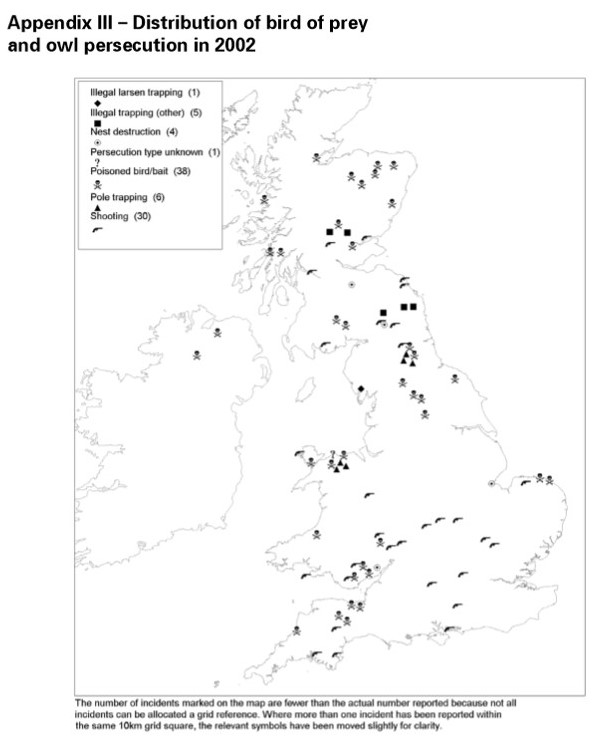
RSPB use consistent spatial and temporal rules to decide how raptor persecution incidents should be recorded. This same method is applied to the WIIS toxicology data to produce wildlife crime incidents. The Glanusk case you mention in your blog provides a good example. During 2012 and 2013 a number of poison baits and victims were discovered on the Glanusk Estate, Wales over a twelve month period at a number of different locations. Using our rules we have mapped this as a total of 13 incidents. The RPPDG map has not included the poison baits and has grouped the raptor victims into a single incident.
RPPDG members, with the exception of NERF, had agreed the following phrase within a statement to go with the map ‘The inclusion of all categories of confirmed raptor persecution incidents (including e.g. poison baits, confirmed attempted incidents) will be considered for future updates’. We are disappointed that this clarification was not included and only became aware of this omission when the Defra media release was actually put out. I have tried to call Defra this morning to ask why this was omitted but have been unable to contact the relevant person. We were also surprised to see that Defra had linked the RPPDG map as a tool to support their Hen Harrier Action Plan. We were not aware that this was their intention, this was not part of the prepared RPPDG statement, and RSPB do not accept this is a valid claim.
RSPB believes that joint initiatives that help raise the awareness of raptor persecution are highly worthwhile and has invested significant time and resource supporting the NWCU and NE in the production of the RPPDG map. However, we do not accept the claim that this map by itself will enable the police in England and Wales to crack down on enforcement where it is needed most, as it is not providing anything we didn’t know already. RSPB has been publishing maps and details of confirmed incidents for over 20 years, in addition there is a huge amount of intelligence information gathered by RSPB and the statutory agencies plus a wide range of published work on raptor ecology and links to persecution. For example, it is clear that land on and around intensively managed grouse moors in the north of England are areas where species such as hen harrier and peregrine falcon are most at risk from persecution.
We believe the production of reliable and publicly accessible raptor persecution maps is a valuable initiative. Going forward, we hope future maps will include all raptor persecution incidents and that the toxicology results from WIIS will be properly categorised into wildlife crime incident data. Maps should also clarify whether any data has been omitted.
In order to make meaningful inroads into this difficult problem, the RSPB believe the key issue for the government to address is improving accountability on sporting estates. Key recommendations mentioned in our recent Birdcrime report include: –
‘Introduce a system of licensing for driven grouse shooting. Self-regulation has been given a chance but is not working. Therefore we propose introducing a fair set of rules in the form of a licensing system and code of practice, underpinned by law, to ensure shoots are operating legally and sustainably. This would also provide an effective deterrent to criminal activity, including loss of a licence to shoot in the most serious cases’.
‘Ensure shoot owners and managers can be held accountable for the actions of their gamekeepers by extending the vicarious liability legislation employed in Scotland to the rest of the UK’.
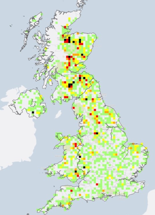
Just for the record, our first Birdcrime type annual report started in 1990, and first map of confirmed persecution incidents was in the 1994 report. I have attached a map of confirmed raptor persecution incidents from 1990 to 2016 (including RSPB & WIIS data) – this has 2545 data points (incidents for which we have a grid reference). As these are just the very tip of the iceberg, it is a rather sobering thought that there will undoubtedly have been tens of thousands of undiscovered and unreported confirmed incidents during this same period.
Guy Shorrock, RSPB Senior Investigations Officer