
[UPDATE 27th August 2018: The three maps below have now been updated to account for the inaccurate grid reference of one ‘missing, fate unknown’ hen harrier – now accurately shown to have ‘disappeared’ in North York Moors National Park, and not in Bowland AONB]
Well, well, well.
The Westminster Government’s statutory nature conservation agency, Natural England (NE), has chosen to publish its long-awaited hen harrier satellite tag data late on a Saturday evening of a Bank Holiday weekend. No announcement, no fanfare, just quietly uploaded to the DEFRA website, probably hoping that nobody would notice.
After having a preliminary look at these data, it’s no wonder NE doesn’t want to shout about them because they validate our long-held view that NE has been shielding the hen harrier-killing criminals within the driven grouse shooting industry for years, instead of dragging them before the courts and closing down their filthy ‘sport’.
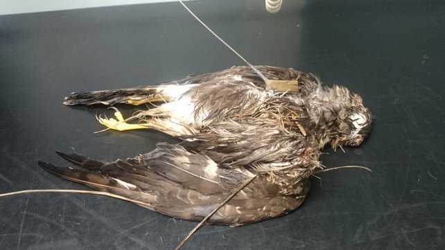
Photo of a satellite-tagged hen harrier. A post-mortem revealed it had been shot.
NE has been satellite-tagging hen harriers since 2007 and a lot of them have ‘disappeared’ in suspicious circumstances (e.g. here). As many regular blog readers will know, we, and others (notably Mark Avery) have been asking NE to publish these hen harrier satellite tag data for a long time. We came quite close to getting the information from this publicly-funded research about a year ago, when NE published part of its ten-year data set but crucially, it excluded all meaningful grid references and any information about the land use in the areas where these hen harriers had ‘disappeared’.
We accused NE of a cover up (see here and here) and pursued the data via many FoI requests but all to no avail. NE told us that as the 11-year NE-funded PhD study had finally been ditched (here), external experts would instead be analysing the data and we could expect the results to be submitted for peer-review publication in 2018.
The findings of that study by external experts were presented at an international ornithological conference in Vancouver yesterday morning, and NE, realising it could no longer justify withholding the data without facing another legal challenge, published the updated satellite tag data late last night.
The new hen harrier satellite tag data have been published on the DEFRA website here
The update is the same spreadsheet that NE published last September but now, importantly, also includes six figure grid references for the ‘last known fix’ from the satellite tags of most of the 59 hen harriers tagged by NE between 2007-2017.
We haven’t had time to look at these data very closely but for now we’ve produced some quick and dirty maps to show the distribution of ‘missing’ hen harriers and those that have been found dead, confirmed to have been killed illegally. Remember, these are the hen harriers that have been satellite-tagged by NE – the map does not include the data from RSPB’s Hen Harrier LIFE Project, so these maps will show an even bleaker picture once the RSPB has analysed the data from its tagged birds.
Here’s the overview map:
[Red star: HH found dead & confirmed illegally killed; Orange star: HH missing, fate unknown; Yellow star: Hen Harrier ‘John’, missing, fate unknown; Black star: hen harrier missing fate unknown but grid reference withheld]

The reason hen harrier John (yellow star) has been highlighted separately is because on NE’s updated spreadsheet, the data are only presented up to September 2017, and so John is shown as still being alive. However, we know that John ‘disappeared’ on Threshfield Moor in the Yorkshire Dales National Park in early October 2017 and so now joins the many others classified as ‘missing, fate unknown’.
The three black stars represent hen harriers that are listed in NE’s data set as ‘missing fate unknown’ but the grid references for these three harriers have been withheld, and the birds’ last known fix locations are given as ‘Bowland’, ‘Bowland’, and ‘Sheffield’. Presumably there is good reason to withhold these grid refs (perhaps they identify commonly-used roost sites?) so we’re not going to quibble about that. Consequently, the black stars are not placed accurately, just in the general area of ‘Bowland’ and ‘Sheffield’ (and presumably ‘Sheffield’ refers to a location close by, perhaps in the Peak District National Park).
You can see from this first overview map that there appears to be quite a bit of ‘clustering’ of last known fix locations in Yorkshire and Bowland, so let’s have a closer look at a regional scale:

Gosh, there does seem to be a lot of ‘missing’ hen harriers clusted in the Yorkshire Dales National Park, Nidderdale Area of Outstanding Natural Beauty, and Bowland Area of Outstanding Natural Beauty – all highly designated protected landscapes.
Shall we look a bit closer?

And there you have it. A suspicious spatial clustering of ‘missing’ or confirmed persecuted hen harriers in the Yorkshire Dales National Park, Nidderdale AONB and Bowland AONB – all areas where the landscape is dominated by intensively managed driven grouse moors.
Haven’t we seen this suspicious spatial clustering somewhere else? Ah yes, the map that shows the ‘missing’ satellite-tagged golden eagles in Scotland, where the spatial clustering appears in some areas that are intensively managed for driven grouse shooting.
Imagine that.
What’s that quote? “You can hide the bodies, you can hide the tags, but you can’t hide the pattern” (Dr Hugh Webster).
Looking at NE’s data spreadsheet, 47 of the 59 hen harriers satellite-tagged by NE between 2007-2017 are ‘missing, fate unknown’. That’s a whopping 79.6%!
Now obviously, these last known fix location data are of great interest to us and we await the publication of the full scientific analyses of all the tag data with great interest. But perhaps what is more interesting is what these data reveal about NE’s complicity in shielding the criminals within the grouse shooting industry.
Knowing full well what its own satellite tag research was showing, why has NE suppressed these results for so many years whilst working in so-called ‘partnership’ with the grouse shooting industry and sat back in silence whilst those same grouse shooting industry representatives have consistently denied, even in Parliament, the extent of their industry’s role in the systematic killing of hen harriers?
More blogs on this to come.

Truly shocking, and a great piece of analysis in only 24 hours. The fact that 47 of a sample 59 harriers were killed in such a short period of time is cause for even graver concern, and illustrates why the Hen Harrier is such a rare breeding bird, especially in England. The circumstantial evidence that grouse shooting interests are flagrantly responsible for the great majority of suspicious deaths may not in itself lead to successful prosecutions, but is so overwhelming that it justifies a serious crackdown by the authorities. I look forward to further instalments.
An FOI of the birds found dead/missing in yorkshire showed that none reach an age to breed themselves. All but one “disappeared” within a year of tagging. It is an absolute disgrace that this agency which is supposed to be there to protect OUR wildlife has taken so long to publish this and only when it had no other choice. The YDNP/nidderdale AONB patterns pretty much mirror the data produced in the YDNP bird of prey evidence report for Red Kite.
National Parks ,Duke Of Westminster Land ,Lack of RSPB concern ,Is there an ongoing pattern ?,The lack of action ? Silence & Hiding of Information , Time to expose the complicity , hypocrisy ,of those whom are charged , funded to protect wildlife , the countryside ,name individuals ,the many statutory , charity organisations whom are silent ,complicit ,the perpetrators ,the licensed shoots ,The main stream media , nature programing ,Governmental oversight ,Is this information known ,available ? & is there going to be National Press Releases ,Demands Calls For Aggressive Action Against All Concerned ???? I`m not surprised at these findings it`s the same failings , the same perpetrators who think & usually are above The Law .
What’s with the cluster on the IOM?
There is a surprisingly large population on the IoM. A quick search suggests that at least of two of the tagged birds are believed to have died of natural causes.
https://www.bbc.co.uk/news/world-europe-isle-of-man-41188218
But these stars are supposed to represent the last known signal fix for HH with a designation of fate unknown. So presumably these 4 stars represent 4 harriers where their last known fix was on the IOM and their bodies were never recovered. Correct?
If that’s not the case, and these stars represent last known fixes of HH that were subsequently found many miles away, where does that leave the remainder of the data and the accuracy of it?
Also, could someone confirm the efforts NE go to to try to recover tags? Are they making real efforts to recover them, especially compared to others like the rspb for their tags, or is it easier simply to write them off as fate unknown?
Have any FOI questions been asked in this regard?
I have heard that the IOM isnt totally free from persecution
A big thank you to you and all who have and are persisting in forcing the ‘powers that be’ to release this data. You shouldn’t have to do it! I hope the perpetrators and those who protect them ( they know who they are, and no doubt read this blog!) finally realise their days are numbered ‘crime-wise’, and I hope, ‘sport-wise’. Time to live in the C21.
Well I guess we all knew this was what the data was going to show. Hopefully forcing it in the public domain might encourage the those supposed conservationists who sign up to sham “partnership” agreements with the grouse botherers to finally decide which side they are on. The fact that they are almost all being killed in National Parks and AONB should be a national scandal.
Wow that is a really depressing to see all those stars.
And here’s a reminder, for any newer visitors to this blog, of the sort of thing recorded as going on on a North Yorkshire grouse moor. Not a satellite tag case, but still graphically indicative of gamekeeper attitudes:
https://raptorpersecutionscotland.wordpress.com/2017/08/10/video-of-marsh-harrier-persecution-on-north-yorkshire-grouse-moor/
Absolutely disgusted with NE. Surely these results emphasise (what’s already bleedin’ obvious) that they are not fit for purpose in protecting the hen harrier in England. Can we crowd fund an action to remove NE hen harrier ‘conservation’ as the species status in England has no time for their shady goings on? Monitoring of the species needs to be removed from NE entirely and given to the RSPB and/or raptor study groups. Well done, RPUK, for your vigilance and rapid response to this scandal.
You must have been burning the midnight oils to prepare this report and thank you for doing so.
It saddens me to hear of so much constant persecution and we all know this is just the tip of a very large iceberg.
Is it any wonder that despite the record number of young in recent years (certainly in Bowland) the thoughts soon turn to ‘I wonder how many if any will survive’?
I am sure RPUK will be going into this into more detail but how does this fit in with the HH Action Plan. First of all the approvers of the plan must have been known about these clusters but it was to my knowledge not included in the plan. That is decidedly dodgy, Secondly now that it is known and the data is published how can the plan continue without incorporating this ‘new’ data into the plan which would lead to only one conclusion to drop the re-introductions and brood persecution or at the very least drop any action until a new plan has been drawn up?
Withholding this information seems even more dodgy when NE asks other countries to donate young Hen Harriers to the introduction scheme. I would be surprised if there wasn’t a law that covers this kind of withholding of crucial information. If there isn’t there should be.
All very interesting although of course many of us knew the gist of it some considerable time ago. The situation in the Yorkshire dales/ Nidderdale AONB looks even worse if you plot the radio tagged bird information too, coupled with the fact that several RSPB tagged birds have gone down in the same general areas. Yes radio tag data is slightly less accurate but nonetheless important in part because more birds were thus fitted compared to satellite tags. NE have had this data of course since the beginning and yet the only gov’t response has been the Hen Harrier recovery plan which is in large part a sop to the grouse industry, treating harriers as a problem for grouse moors rather than treating it properly — grouse moor management is a criminal problem for Hen Harriers. There can be no hiding now for the apologists for grouse shooting. This combined with Peregrine data for the English uplands should finally kill the lie that grouse management is a good conservation tool with positive outcomes for wildlife.
I’m no fan of driven grouse shoots or the rich and famous complicit in the undoubted criminal activity going on in connection with it.
However as someone who likes to base things on sound science I’d be grateful of an explanation of how this doesn’t just tell us that these areas are good habitat for Hen Harriers and that many of the tagged birds die – perhaps due to low survival of young birds. I.e. is there any analysis of where the birds were tagged, how many have been tagged, how do survival rates compare with other areas, etc. The cluster on the Isle of Man is something that needs addressing in this context. No doubt this kind of consideration will be thrown back in our faces by those who benefit from the continuation of driven grouse shooting.
A serious scientific investigation (not a Langholm-type set-up) needs to be taken on by NE and SNH, but will it ever happen? There is now so much cynicism over the sincerity and professionalism of both departments, that hardly anyone is likely to take it seriously. How did this happen? Is it right or democratic for Government to interfere with the process of using robust science to determine the truth. Or for executive decisions to be made by puppets installed by Governments made up of a class of MPs who inherently support grouse shooting and blood sports in general? The fight needs to be ranked up to a new level. We owe that to the hen harriers.
Hi Seb,
You’re right to question this. Without having access to ALL the sat tag data, instead of just the last known fix, we can’t tell whether the spatial clustering is a result of these birds spending disproportionately more time in these areas. We presume that those additional data will be analysed by the researchers conducting this study, in the same way this point was addressed in the Golden Eagle Satellite Tag Review. In the Golden Eagle Review, the researchers undertook various spatial analyses and determined that the clustering of ‘missing’ eagles on grouse moors was NOT as a result of the birds spending more time in those areas.
Grid reference for bird 909691 is wrong as this grid ref is NOT in the North York Moors it should be SE not SD and the last 3 numbers may also be transposed I believe from other information that they should read 944. I hope that NE have the rest of it right!!!!
Thanks Paul (and for your emails, too).
We’ve now updated the maps to take account of this mis-assigned grid ref, so this hen harrier is now shown on the maps as having ‘disappeared’ in the North York Moors National Park, instead of Bowland AONB.
We are aware there are other inaccuracies in NE’s data set so we’ll await and update from them before changing any more maps.
And these are only the tagged ones. Think how many others will have met the same fate and gone unrecorded.
I wonder what proportion of a year’s new birds are tagged.
This is all the more damning because this includes only the birds tagged by NE – it takes no account of birds tagged by others (e.g. By RSPB or in Scotland) and that may also have been recorded missing in areas of England? – is there any way of combining the data with other reliable sources when this recent “information” is better ratified ? – let’s have NE get their cards on the table and finally attempt, with meaningful data, to sort this out. Anyone looking at this might wrongly form the impression that the number shown as lost in this data is the total lost when shows only NE tagged birds lost.
Playing devil’s advocate here, but if (and presumably the tracking data will show whether or not this presumption is correct) most hen harriers spend most of their time on or close to ground managed for driven grouse shooting then isn’t it to be expected that most of them will die or disappear there too?
This data will only be significant if it shows that the birds don’t frequent driven grouse areas but if they do venture there they are likely to disappear.
Usually if a bird dies of natural causes it doesn’t just disappear. Not sure exactly what method NE were using but I know the RSPB has been able to find naturally dead tagged harriers because the tag keeps transmitting and leads them straight to the body.
When birds and their tags just completely disappear off the face of the earth, with clusters of such disappearances in areas with a lot of driven grouse moors and a known problem with persecution, then that’s a sign of something dodgy going on.
The second and third maps down here shows the range of the birds
https://www.gov.uk/government/publications/hen-harriers-tracking-programme-update/hen-harrier-annual-tracking-update
Maybe what is required is a cover all map highlighting suitable (breeding) habitat on a country wide basis and overlaid with the location of driven grouse moors.
The first thing it’s worth reminding ourselves of is that in 2008, Natural England produced the report A Future for the Hen Harrier in England”, and unequivocally concluded that it’s monitoring work since 2002 proved that “Persecution is prime cause of hen harrier disappearance”. That quote is from the headline of the NE discussing this. The blame is laid firmly at the door of shooting interests.
http://webarchive.nationalarchives.gov.uk/20110314111327/http://www.naturalengland.org.uk/about_us/news/2008/221208.aspx
My point is that the above information about the latest release of satellite tag data only further confirms this, and as can be seen the 2008 conclusions were also partly based on the disappearance of satellite tagged Hen Harriers over shooting estates.
To solve a problem, you first have to understand it. The primary difference between 2008 and now, is that we have a different political regime, a political regime of a party where these landowners are either senior members, or have a lot of influence with. There’s a lot of talk about Natural England not being fit for purpose, and taking all the flack. But the elephant in the room not being acknowledged is that in 2010, NE got new political masters, who are for all intents and purposes the party of the grouse moor owners. After all PM from 2010-16 was an avid shooter, even if this was carefully hidden from the public. Likewise there is a widely circulated image of the current Environment Secretary posing with a shotgun in one hand, and a shot pheasant in the other.
In other words, the rather obvious and hardly revolutionary conclusion, that the problem is not so much with Natural England, who were able to openly admit the cause of the problem in 2008, but the political masters of NE who don’t want to upset their party political friends and grouse moor owners, by shining a public light in their persistent organized wildlife crime.
I honestly believe that ignoring the conclusions of that report you mention and hiding this ‘new’ data for so long is criminal. I believe it is an offence to behave in such a way that results in the death of a Schedule 1 raptor. Withholding this scientific evidence for so long has resulted in many more deaths of Hen Harriers (and it could be argued Peregrines etc.).
I am not being fanciful. Forestry Commission Scotland has published guidelines which warn that felling around White-tailed Eagle nests which are subsequently blown down could be a crime.
‘If a tree containing a habitually-used nest blows down as a direct result of a clear felling operation, e.g. where the nest tree is left isolated on a clear fell site, this could be regarded as reckless behaviour.’
Click to access fcpn101.pdf
I entirely agree with you. I call it institutional corruption. It’s deliberately turning a wilful blind-eye, which is a well known legal contrivance, but not legal, where someone who has a duty of care turns a blind-eye to what is happening. Given this report from 2008, this administration cannot be unaware of the situation. It’s all very knowing. You’d have to be incredibly stupid and ignorant not to be aware of what is happening.
So much respect for your work, your tenacity, your VERY late nights.
Thank you.
Thanks Paul, appreciate your thoughts and this one was a particularly late night! However, we’re not the only ones working on this stuff – Mark Avery has also put in a significant amount of time and effort in trying to get this info out of NE, also over a number of years. And then there’s all the good people who share/retweet our blogs, helping to spread the word and increase the pressure.
… and your humility! Massive respect and gratitude to you.
” A few bad apples
Utter nonsense. This is widespread organise crime for financial gain.
The game bird shooting industry is clearly able to self regulate or work within a legal frame work.
This is a national disgrace
“clearly not able” surely…
Yes thank you.
Please can somebody inform us if they have any idea why there is none of these stars in the north York moors?
Is the Yorkshire Dales worse for persecution than the north York moors?
Is it this national park that is suppressing all hen harriers as they move around the country? I accept there is harriers gone missing around the country but more in the Yorkshire Dales than anywhere else.
There are are so many errors in this data.
Paul Irving has pointed out that 90691 is wrong.
I can see that 137372a has a wrong gridref and 73591 has either the place wrong name or the wrong gridref and i have only looked at a few.
if these errors make it into the final publication it won’t be worth much.
ID94591 and ID58870 both have their last known transmission 3km from the centre of the overlap of the last known transmissions of Hope and Sky. I have posted this already on Mark Avery’s blog but i think it is important enough to cross post that surely this is withholding evidence of a raptor crime!
Also 58945 has the last transmission given as SD567780, which is near Hutton Roof, Cumbria but is given as Yorkshire Dales
73589’s Last Known Transmission was, if the gridref is correct, in North Yorkshire not ‘North Pennines, Cumbria’.
Sorry for cross posting. I am hoping RPUK or Mark are keeping a record of all the mistakes to send to the authors and NE. What should i do if i find more errors?
73588 LKT is according to the gridref in Nidderdale not Bowland.
58946** LKT is according to the gridref in Lowther not Langholm
74843 LKT is according to the gridref in Wensleydale not Niderdale (but not that far off)
I will cross post to Mark in case one of you is collateing this info.
All this shows that the incomplete data we were sent the first time, with name of location only, was totally inaccurate
Thanks, Prasad. We’re not doing anymore on this issue until NE has corrected the data.
If they can’t provide a simple grid reference, to what other inaccuracies are the data prone?
Those two Hen Harriers going ‘missing’ within 3km of Sky and Hope’s ‘disappearance’ is even more suspicious when those two birds last transmissions were only 3 days apart (exactly like Sky and Hope)!! We are supposed to believe by the grousers that first Sky and Hope ‘disappear’ at the same spot and at the same time in 2014 and that in 2010 the exact same thing had happened at the same spot! Really ‘cover up’ is too mild a term, this is more like collusion.
I wrote to Ne to complain about their secrecy and it’s consequences.
They replied ‘In all cases, in England and the IoM, when one of Natural England’s satellite tagged Hen Harriers stops transmitting the Police are notified straight away and a thorough search of the area is made’
That is very interesting but opens up new questions including what the police have done regarding these 4 ‘missing’ birds. I also wrote to the police but if it is ‘ongoing’ i doubt i will get a reply. In other words another black hole of information
Strange that the NE Hen Harrier satellite tagged data-sheet mentions nothing suspicious about birds failing. Why do they downplay the criminal aspect?
In the data-sheet it states
‘Missing Fate Unknown includes:
(i) radio-tagged birds that left the study area. The vast majority of Missing Fate Unknown’s are radio-tagged birds, this is not surprising given the mobility of Hen Harriers and our relatively small study area.
(ii) radio-tagged and satellite tagged birds that were recorded after the battery ran out or transmissions had stopped.
(iii) satellite tagged bird that died in such a position as to render the transmitter hard to locate and recover. The satellite transmitters depend on light to recharge, and operate on a 10hr on 48 hr off duty cycle. Therefore, when a bird dies there is only a small chance that it would happen whilst the transmitter is transmitting with enough charge to enable transmission of coordinates and a signal to enable retrieval. If the bird dies in the off cycle of the transmitter then it could have travelled many kms to its final resting place from the last transmitted coordinates. If this final resting place is in long vegetation, and/or the bird is lying on its back with little or no light available the solar panel it will never transmit again and the bird would fall into the Missing Fate Unknown category. ‘
Well done for a review of this flawed data in a short time. NE had up to 11 years to let the public know what happened to these birds and have failed to do so. It is evident from what little you have released that NE are sheltering the people with whom they have decided to associate, the organised criminals who ended the lives of these birds.
I should have said “many of these birds”. I’m prepared be honest, unlike NE, who from their delay (up to 11 years), the timing of the release their refusal to give further detail, the errors, the on going delay to the scientific report the choice of Canada for the scientists to give an update, all make clear a shocking deliberate dishonesty.
Organised crime being covered up by a government agency, In any other country heads would role
I noted that there was an incident in the Lincolnshire Wolds, my area. Do you have any information on this please?
You can look at the data for yourself here https://www.gov.uk/government/publications/hen-harriers-tracking-programme-update/hen-harrier-annual-tracking-update#hen-harrier-data-update-august-2018
It seems to me that DGS industry will simply argue that, since the birds spend most of their time on driven grouse moors, it is inevitable that the signals disappear (for whatever reason) on those moors. Depending on actually how widespread the killing of hen harriers is routine, it may be possible to link these disappearances to specific land managers or estates. What you really need is the time resolved data, which may show that the harriers roam around widely and that there is a strong correlation between their disappearance and a particular land management regime. At the moment it’s an assumption that the birds have roamed around widely and then disappeared on land managed for DGS. If I was a reviewer for this, as a scientific paper, this would be my comment.
Hi Gerard,
Yes, good point, see above comment we made to Paul Fisher. We expect the researchers to analyse this for their peer-reviewed paper.
At the moment we’re constrained as to what we can conclude from the very limited data NE has released.
Brilliant work. However, the Isle of Man orange stars are misleading. Of the birds tagged on the island: Hetty (2015) died on the island but no evidence of malintent was apparent; Aalin (2016) died near a grouse moor in Wales; Grayse (2017) died on the island of natural causes; Mannin (2017) died in the sea south of Kirkcudbrightshire. For all four birds, the carcasses were recovered and the satellite tags retrieved! Hope that helps. And credit where it’s due … IOM DEFA is doing a far better job than DEFRA or N and helping Manx BirdLife greatly.
Apologies. Correction. Aalin’s body and tag were never recovered. Hence adding to the pattern of birds and tags disappearing in unexplained circumstances near grouse moors. Three out of four have been recorded.
Hi Neil,
The data in the map are NE only tagged birds, the four missing fate unknown birds were tagged in 2007. 1 bird disappeared in 2007, 2 in 2008 and 1 in 2009 so I imagine that we are talking about four different tagged Hen Harriers. Do you have any details of these birds?
“you can hide the bodies, you can hide the tags” and my god they even got a government agency to hide the details,
Gordon Bennet, I have just looked at the data in conjunction with a couple of map applications. It looks like one estate in Nidderdale AONB, has five either missing fate unknown birds. Talk about raptor disappearance black holes.
“has five missing fate unknown birds” ……….sorry.
Correction it was the Who Owns England website being a bit slow. 3 Missing fate unknown harriers on the estate and 2 nearby.
and then there are two disappearances on an adjacent moor, but with different owners, still could be the same management company. So in this little cluster in the Nidderdale AONB there are 7 missing birds. Then just to NW around Thwaite, there are a further 4 and slightly to the North an additional 2. That’s 14 missing birds in just 400 Km^2. What percentage of the population are tagged? Extrapolating how many birds in total could be disappearing in this area. It’s staggering.
Wasn’t there a report that it tends to be the agencies who prepare the land for shooting, rather than the gamekeepers themselves, who may be the culprits ? Is there another correlation to be explored there ?
Obviously, with the permission of the owners
Any rough estimate of what percentage of UK hen harriers are tagged?
There will be additional continental harriers passing through as well.
Funny the old misinformation
Food supply
Habitat
Weather
Land use
Etc etc
Are being seen through……..
PERSECUTION
is the main reason for the loss of our raptors.
I have no doubt that NE are being put put under pressure by their lords and masters to not investigate the matter too greatly. As far as I am concerned the pressure they are being put under by those with shooting interests manifests itself in the fact that they issued licences to cull buzzards where they were purported to be causing problems to shoots. Until we get a change of regime can’t see things changing.
Probably best the PhD never came out if these clowns dont even know how to generate a simple grid reference
Someone sent me the civil service code.
if only..
https://www.gov.uk/government/publications/civil-service-code/the-civil-service-code
DEFRA is a civil service but not sure about NE but ‘When Natural England has vacancies they’re listed on Civil Service Jobs’
https://www.gov.uk/government/organisations/natural-england/about/recruitment